
WHAT IS KARST?
Etymology
by Neven Kresic (Water in Karst, Mc Graw Hill, 2013, p. xiii)
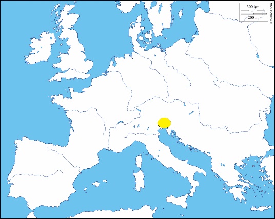
“Karst is a scientific term named after the geographic district between Slovenia and Trieste, Italy, which has a very distinct landscape. It is a Germanized word for “carso” (in Italian) and “kras” in (Slovene); all the three words are derived from the Indo-European word “kar” or “karra”, which means rock…Some common words from the Slavic languages of the Karst region have become international scientific terms describing karst features, mainly thanks to the Serbian geomorphologist Jovan Cvijić who was the first to defend a doctoral thesis and publish a scientific monograph exclusively devoted to karst (Cvijić, 1893).” (Figures 1,2)
Landscape
by Derek Ford & Paul Williams (Karst Hydrogeology and Geomorphology, Wiley, 2007, p. 1)
“We may define karst as comprising terrain with distinctive hydrology and landforms that arise from a combination of high rock solubility and well developed secondary (fracture) porosity. Such areas are characterized by sinking streams, caves, enclosed depressions, fluted rock outcrops, and large springs. Considerable rock solubility alone is insufficient to produce karst. Rock structure and lithology are also important: dense, massive, pure and coarsely fractured rocks develop the best karst…Experience shows that many hydrogeologists mistakenly assume that if karst landforms are absent or not obvious on the surface, then the groundwater system will not be karstic. This assumption can lead to serious errors in groundwater management and environmental impact assessment, because groundwater circulation can develop even though surface karst is not apparent.”
Features
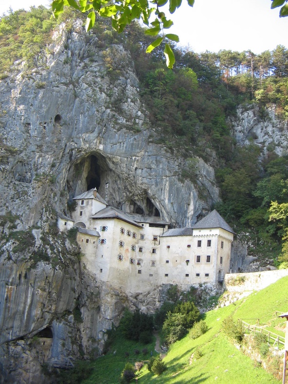
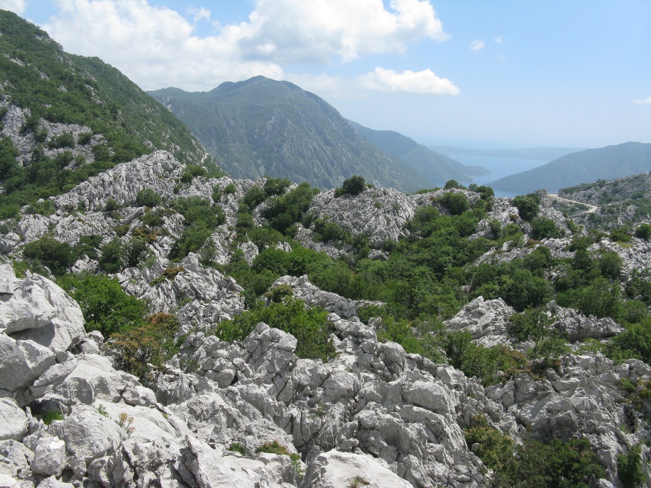
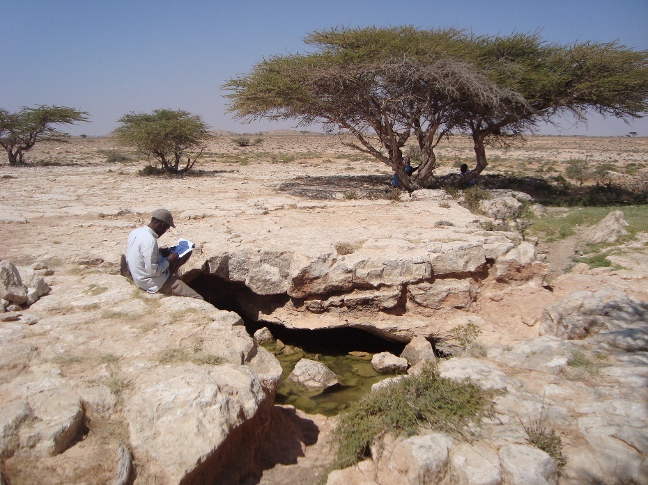
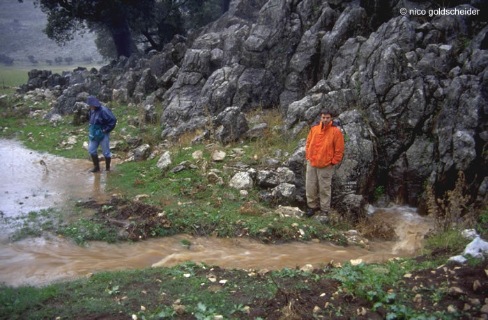
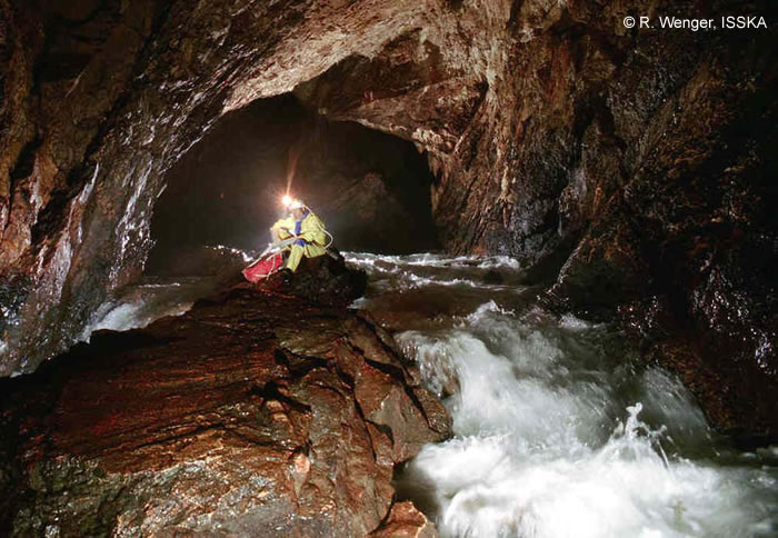
The list of karst features resulted from dissolution and erosional karstification processes is long and includes variety of micro and macro surficial and underground objects. Among them are karrens or lapies, dolines or sinkholes, uvalas, poljes, blind and hanging valleys, sinking streams, caverns (Figure 3), ponors or swallow holes (Figure 4), potholes, caves (Figure 5).
Glossary for these and many other terms used in karstology is available HERE (maintained by Alexander Klimchouk et al.)
Classification of karst aquifers
by Zoran Stevanović (Karst Aquifers – Characterization and Engineering, Springer, 2015, p. 25-29, 49)
“Sedimentary karstic rocks can be generally classified into the two major groups:
- carbonate rocks
- evaporite rocks
The carbonate rocks are formed from calcium and magnesium minerals: calcite, dolomite, aragonite and magnesite, and include the two major groups:
- limestones (CaCO3), and
- dolomites (CaCO3 x MgCO3)
with a wide range of varieties.
To the evaporite group belong rocks and minerals which contain SO4 or Cl anions:
- anhydrite (CaSO4),
- gypsum (CaSO4 x 2H2O)
- halite (NaCl), and
- sylvite (KCl).
The dissolution of calcite (1) dolomite (2) and gypsum (3) is expressed by the following equations:
CaCO3 + H2O + CO2 ↔ Ca2+ + 2HCO3 (1)
CaMg(CO3)2 + 2H2O + 2CO2 ↔ Ca2+ + Mg2+ + 4HCO3 (2)
CaSO4 x 2H2O → Ca2+ + SO4 2- + 2H2O (3)
According to the dominant type of rocks of which karstic aquifer consists the following classification can be made:
- Carbonate karst aquifer,
- Dolomitic karst aquifer,
- Marble karst aquifer,
- Chalky karst aquifer,
- Anhydritic karst aquifer,
- Gypsum karst aquifer,
- Halitic karst aquifer.
Taking into consideration structures and hydrodynamic properties, there are:
- Unconfined karstic aquifer (Figure 6),
- Confined karstic aquifer,
- Semi-confined karstic aquifer.”
Hydrogeologic characteristics of karst aquifers
by Nico Goldscheider (web site of KC, 2009-2013)
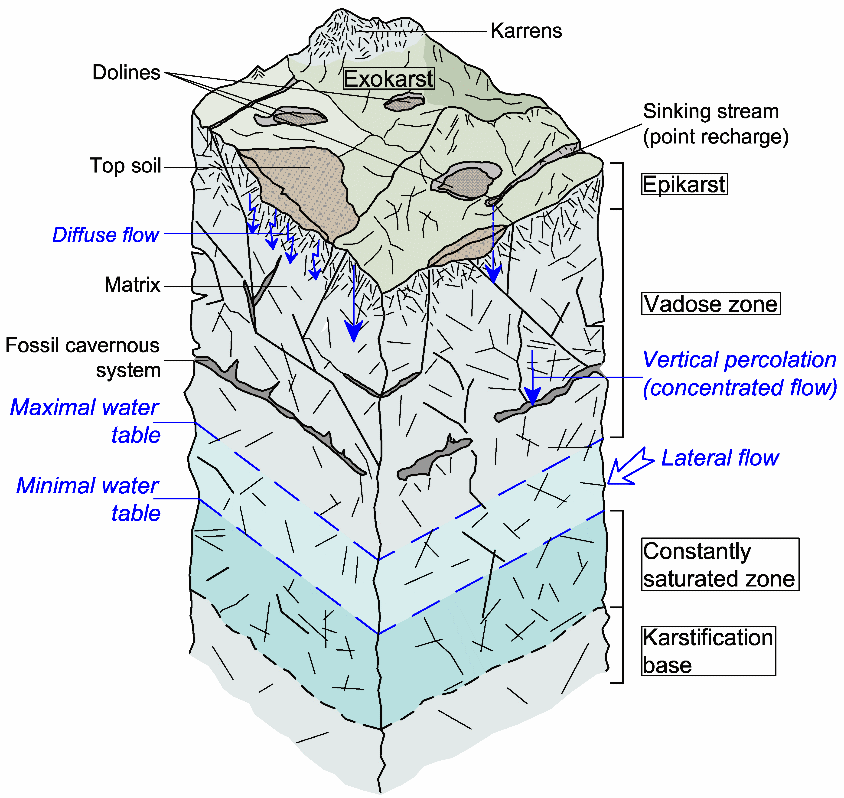
“Evolution: Karst aquifers form by flowing water containing carbon dioxide (CO2) which dissolves carbonate rocks. Therefore, there is a close relation between aquifer evolution, the formation of caves (speleogenesis) and groundwater flow.
Individuality: Although there are many similarities among different karst systems, every karst system is also a special case and generalisation is difficult. Figure 7 presents a simplistic model of a typical karst aquifer.
Heterogeneity: The properties of karst aquifers greatly vary in space. There may be large quantities of water in a cave, but a borehole a few metres away may be completely dry.
Anisotropy: The aquifer hydraulic properties depend on the orientation of geologic fabric elements; for example, the hydraulic conductivity is typically high in the direction of large fractures and conduits, but may be low in other directions.
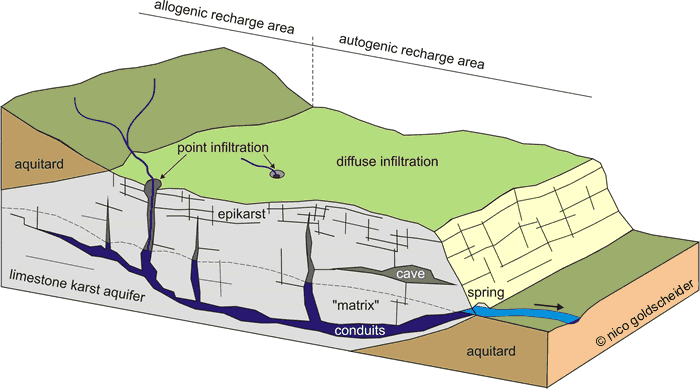
Duality of recharge: Recharge water may originate from the karst area itself (autogenic recharge) or from adjacent non-karstic areas (allogenic recharge).
Duality of infiltration: Infiltration occurs through the soil and unsaturated zone (diffuse infiltration), and may also be concentrated via swallow holes/sinks (point infiltration).
Duality of porosity and flow: There are two or even three types of porosity in karst aquifers: intergranular pores in the rock matrix, common rock discontinuities such as fractures (fissures) and bedding planes, and solutionally-enlarged voids such as channels and conduits developed from the initial discontinuities. Whereas groundwater flow in the matrix and small fissures is typically slow and laminar, flow in karst conduits (caves) is often fast and turbulent.
Variability: The water table in karst aquifers can sometimes fluctuate 10s or even 100s of metres in short periods of time, and karst springs typically show rapid variations of discharge and water quality.”
Karst within the context of regional flow systems
by Judit Mádl-Szőnyi (White, 1969; Mádl-Szőnyi and Tóth 2015, Palmer 1991, 1995, Klimchouk 2000, 2007; Goldscheider et al. 2010)
Epigene karst: this is the product of the corrosive effect of infiltrating groundwater on carbonate aquifers. It can evolve in shallow, basically unconfined carbonates and is related to dissolution effects of cold water in local flow systems. These are the typical karst areas with characteristic surface and subsurface features.
Deep karst: Karst where it extends to considerable depths below base level.
Hypogene karst: Generated by deep energy, fluid and gas sources including retrograde calcite solubility, mixing corrosion by different fluids induced by cross-formational flow, and dissolution by geogenic acids. It can evolve in deep confined karst areas associated with lukewarm and thermal water of regional or intermediate flow systems without any significant surface features.
Recommended references for further reading:
Goldscheider N, Mádl-Szőnyi J, Erőss A, Schill E (2010) Thermal water resources in carbonate rock aquifers. Hydrogeol J 18 (6): 1303-1318
Klimchouk A (2007) Hypogene speleogenesis: hydrogeological and morphogenetic perspective. Special Paper no. 1, National Cave and Karst Research Institute, Carlsbad, NM
Mádl-Szőnyi J Tóth Á (2015) Basin-scale conceptual groundwater flow model for an unconfined and confined thick carbonate region. Hydrogeol J 23 (7): 1359-1380
Methods to study karst aquifer systems
by Nico Goldscheider (web site of KC, 2009-2013)
“Due to the characteristics described above, conventional hydrologic and hydrogeologic methods often fail when applied to karst; their adaptations and karst-specific methods are therefore required.
Geologic methods: The lithology, stratigraphy, fracturing, fault pattern and fold structures are crucial to understanding groundwater flow in karst aquifers.
Speleology: Conduits and underground channels are crucial for groundwater flow in karst aquifers. Caves make it possible to enter the aquifer and directly observe and study a part of the conduit-channel network.
Hydrologic methods: Due to the high variability of flow rates of sinking streams, cave streams and karst springs, continuous monitoring of water quantity and quality is crucial in karst hydrogeologic studies.
Hydraulic methods: Potentiometric maps and hydraulic tests in boreholes and wells are widely applied in hydrogeology but require specific adaptations when applied to karst.
Isotopic techniques: Stable and radioactive isotopes can help to identify the origin of the water, determine transit times, and characterise mixing processes.
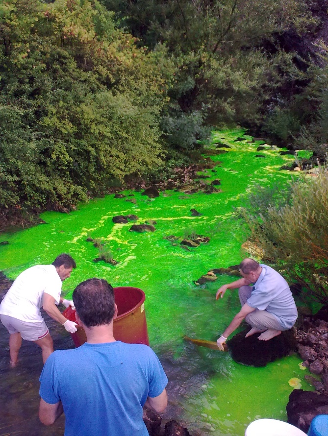
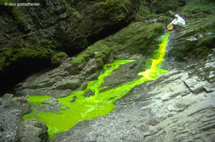
Tracer tests: Tracer tests (Figure 8) are the most powerful method to identify point-to-point connections (typically between swallow holes/sinks and springs), to delineate karst spring catchments, and to characterise flow and transport in the conduit networks.
Geophysical methods: Geophysics can help identify locations for well drilling, investigate subsurface cavities (potential sinkholes) and obtain other information on the aquifer structure.
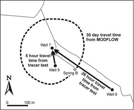
Modelling: Mathematical models can help to better understand speleogenesis, flow and transport in karst aquifers. However, there are examples (e.g. Figure 9) where the application of conventional groundwater flow models in karst environments produced catastrophically wrong results and resulted in delineation of grossly inadequate source protection zones, leading to disease outbreaks, all because the specific nature of karst was ignored.”
Karst groundwater utilization
by Zoran Stevanović (Karst Aquifers – Characterization and Engineering, Springer, 2015, p. 111-112, 116-119, 299, 109-111)
Water quality
“The dissolution of rocks and the duration of direct water – rock contact result in variable groundwater quality at discharge points. The mineral components of karst waters depend upon the composition of the rocks through which water is percolating: Hydrocarbonate (HCO3) – calcium Ca) type of waters is created from the dissolution of calcium carbonate which is a dominant type of water in limestone, while the hydrocarbonate (HCO3) – magnesium (Mg) type of groundwater is present to a lesser extent, and is regularly connected to dolomitic rocks.
Langmuir (Physical and chemical characteristics of carbonate water, 1984) listed processes which control and influence the quality of groundwater before it reaches the spring site or well head. These processes are as follows:
- The composition of the infiltrated atmospheric precipitation;
- Evapotranspiration losses from groundwater recharge and shallow groundwaters;
- The acidity and degree of of undersaturation of groundwater recharge;
- The availability and solubility of carbonate and associated rocks, including halite, gypsum and anhydrite;
- Rates of solution of the rocks and contact time;
- Hydrologic processes such as dilution by fresh water recharge and mixing of dissimilar groundwater;
- Anthropogenic processes, including groundwater pollution by wastes and leachates from solid wastes.
It is almost a rule that groundwater in open karst structures is low mineralized which is a result of the intensive water exchange and rapid filtration. In deeper parts of the aquifer, slower filtration results in an increase in mineralization. This variation is often minimal, but nevertheless indicates a certain differentiation that may be important under specific circumstances (e.g. when pollution is involved).
Therefore, in the case of carbonate karst the quality of natural karst waters is excellent almost by definition: it is confirmed in many places worldwide that water issuing from unpopulated catchment areas on mountain massifs is sanitary and pure while only exceptionally could there be a small amount of bacteria present. But if pollution sources are present in the catchment of an unconfined karstic aquifer then severe hazards follow.
Tapping karst waters
Tapping groundwater is never an easy task largely because we are dealing with an “invisible resource”. The situation is even more complicated, however, when we deal with a non-homogenous and anisotropic aquifer such as karst: it is very often necessary to reach, catch and capture groundwater which circulates through voids or through porous blocks isolated from the rest of the rock mass.
We may distinguish the two main kinds of tapping groundwater in karst:
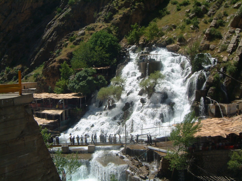
- Tapping karstic groundwater flow at discharge points – springs (Figure 10).
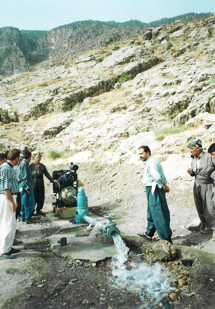
- Tapping karstic groundwater flow within the aquifer catchment – artificial structures such as wells, galleries or other similar structures (Figure 11).
Groundwater is tapped not only to exploit it for drinking, industrial, heat extraction, or irrigation purposes, but also for dewatering in the case of mine pits, urban areas or cultivated land which should be protected from a high groundwater table.
Use for different purposes
The karstic springs are widely utilized as a source of drinking water supply. Many countries utilize karstic springs simply because there are no other alternatives, but in many other countries awareness of their importance and the good water quality they provide is a principal factor for such a decision. The karstic aquifers have a significant proportion of the water supply in the following regions: southeastern Europe (Alps and Carpathians), the Mediterranean basin, the Near East and Middle East, the Arabian Peninsula and Horn of Africa, southeastern Asia, North Africa, the Caribbean basin and Central America, and the southern part of the USA.
Natural drainage of aquifers through springs can cover water demands on a wide scale: from the supply to multimillions of towns at the regional level, to the very local level where the supply to just one or several houses is concerned. Although the latter is not a big problem in terms of amount of water, for the big consumer a very large aquifer and spring discharge are required. There is a wide range of uses of karstic waters. In arid regions in the Near East and Middle East it is, for instance, very common to tap karstic springs and to construct gravity channels for irrigating arable land. Springwater is also widely used for watering animals, and fresh water of good quality provides security for animal health and growth.
The use of karstic waters in hydropower generation by utilizing high hydraulic head is limited mostly to the Alps (Austria, Switzerland), while thermal properties of karstic waters and springs are utilized elsewhere. Finally, the number of karstic springs utilized in the world’s water bottling industry which runs an annual revenue of around $13 billion is very large and karstic aquifers probably lead the list of aquifers where such sources originate”.
Recommended references for further reading:
Bakalowicz M (2005) Karst Groundwater: A Challenge for New Resources. Hydrogeol J, 13: 148-160
Bonacci O (1987) Karst Hydrology with Special Reference to the Dinaric Karst. Springer-Verlag, Berlin, 184 pp.
Burger A, Dubertret L (eds) (1984) Hydrogeology of karstic terrains. Case histories. International Contributions to Hydrogeology, IAH, vol 1, Verlag Heinz Heise, Hannover, 264 pp.
Drew D, Hötzl H (1999) Karst Hydrogeology and Human Activities. Impacts, Consequences and Implications. Balkema, Rotterdam, 322 pp.
Ford D, Williams P (2007) Karst Hydrogeology and Geomorphology. Wiley, 576 pp.
Goldscheider N, Drew D (Eds.) (2007) Methods in Karst Hydrogeology. Taylor & Francis, London, 264 pp.
Käss W (1998) Tracing Technique in Geohydrology. Balkema, Rotterdam, 581 pp.
Kresic N, Stevanović Z (Eds.) (2010) Groundwater Hydrology of Springs. Engineering, Theory, Management and Sustainability. Elsevier Inc. BH, Amsterdam, 573 pp.
Kresic N (2013) Water in Karst. Management, Vulnerability and Restoration. McGraw Hill, New York, 708 pp.
Milanović P (2004) Water Resources Engineering in Karst. CRC Press, Boca Raton, FL, 312 pp.
Palmer AN, Palmer MV, Sasowsky ID (Eds.) (1999) Karst Modeling. Special Publication 5, Karst Water Institute, Charles Town, WV, 256 pp.
Parise, M. & Gunn, J. (eds) 2007. Natural and Anthropogenic Hazards in Karst Areas: Recognition, Analysis and Mitigation. Geol. Soc. London, sp. publ., 279 pp.
Stevanović Z (Ed.) (2015) Karst Aquifers – Characterization and Engineering. Series: Professional Practice in Earth Science, Springer Intern. Publ., 692 pp.
White WB (1988) Geomorphology and Hydrology of Karst Terrains. Oxford University Press, New York, NY, 464 pp.
